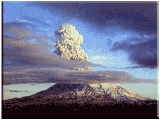
A plume of black ash immediately exploded from the mountain and went straight up into the atmosphere. I have no idea how high the plume went only to know that the ascent was very rapid. (At a later time, a United Air Lines pilot approaching Portland from the south indicated it went to 90,000 ft.) Simultaneously, it appeared that the westerly part of the mountain exploded and the area and sky were dark with the deep gray to charcoal black ash. In a few minutes we were landing at the Portland airport. The sky was not a clear blue that was evident before the eruption but rather a hazy yellowish hue. There was a certain odor in the air that may have been a sulfur odor.
- John H. Lienhard, Eyewitness
On May 18, 1980, Mount St. Helens, located in southwest Washington state, erupted into a billion pieces. Within moments, the largest landslide in recorded history removed more than 1,300 feet from the summit and swept away nearly the entire north side of the mountain. That Pacific Northwest natural disaster unleashed in its path the disruption of thousands of lives, and transformed more than 200 square miles of lush forest into a gray, desolate moonscape.
 Twenty-five years later, the land around the mountain was slowly healing. Nature may be covering the scars of the 1980 eruption, but many witnesses will never forget the phenomenal natural disaster that claimed the lives of 56 people that cool spring morning in May.
Geological tension
Mount St. Helens is situated above the crossing of the ocean-continent subduction boundary of the Juan de Fuca plate and the subducting North American plate. That geological tension has, over millions of years, created Mount St. Helens — an active strato volcano.
A body of magma moved into the shallow part of the volcano between the first earthquakes and minor eruptions in March, and by May 18 had become so pressurized that the north face of the mountain gave way. Magma and ash were then released into the sky.
The slow moving friction of the continental rock of North America, and the oceanic rock of the Juan de Fuca tectonic plate, is slowly refueling Mount St. Helens for another eruption.
Scientists estimate that there is a large reservoir of magma approximately four miles beneath the crater. However, just like the prior days and minutes to May 18, 1980, no one knows enough about the volcano to predict when the next eruption will take place, or for that matter, its severity.
An eerie silence
May 18, 1980, awakened from her night sleep to a tranquil and bright scene of serenity. The gods were surely smiling upon Helens' beautiful surroundings.
Given that it was a Sunday, there were just a few loggers, campers and scientists on the mountain. They were at ease, owing to the mountain's recent inactivity. The silence surrounding St. Helens provided a misleading sense of security for many — including scientists who were totally unaware of what was to come.
Fire on the mountain
On the morning of May 18, Geological Survey vulcanologist David Johnston was taking data readings at what is now known as Johnston Ridge, five miles northwest of Helen's summit. Then Nature unleashed sudden disaster.
David Johnston radioed in at 8:32 a.m. and barked, "Vancouver! Vancouver! This is it!" A few clean breaths of air later, Johnston was struck by 500-mph racing hunks of rock, ice and trees. His body was never recovered.
As the massive landslide raked the land on its way down, the elevation of the mountain dropped from 9,677 feet to its present-day 8,363 feet. The ninth-highest peak in Washington state was suddenly reduced to No. 30.
Flooding followed as the glacial ice and snow on the mountain instantly heated into raging water. The massive movement of rock, ash, water and downed trees swept into Spirit Lake and down the north fork of the Toutle River Valley at speeds in excess of 175 mph.
When the north face of Mount St. Helens was peeled away, trapped gasses immediately found their way to the surface like a shaken bottle of beer that was popped open.
Photographer Gary Rosenquist and his party were camping northeast of Helens at Bear Meadows when the eruption occurred. Rosenquist managed to photograph the scene and live to tell about it. His photos of the eruption are some of the few that were actually recorded that "Ash Sunday."
Rosenquist and the rest of his party survived the eruption, even though the lateral blast was headed straight in their direction at speeds upwards of 650 mph. After crushing ridge after ridge in their direction, the blast suddenly turned, and left the party to camp another day. In only three minutes the blast flattened 230 square miles of old growth forest in a fan shape north of the mountain.
The victims
In May 2000, a memorial plaque was placed in a grove of trees at the Hoffstadt Bluffs Visitor's Center in memory of the eruption victims. Fifty-seven names are etched into the plaque. They were loggers, campers, reporters and scientists.
In all, there were 36 victims brought out of the devastated area. But after all of the searching, rescues and recoveries, there were still many people who were never found. By the third week following the blast, 25 people were confirmed dead, but 47 were still on the missing list. Fortunately, 15 of the missing were later found alive.
Only four of the victims were known to be inside restricted areas set up by federal and local governments — one of them included David Johnston, five miles from the summit.
There was the stubborn Harry Truman (not the late president) who refused to leave his lodge at Spirit Lake and was eventually given special permission to stay. Amateur vulcanologists Bob Kaseweter and Beverly Wetherald, who had permission to take readings near Spirit Lake at their own risk, were lost as well.
The other victims, some as far as 13 miles from the mountain, were in areas considered safe. The thick clouds of ash and raging mud flows caught many people off guard.
Truly a natural disaster
Along with the loss of human life, it seemed the plants and animals in the area were nearly completely wiped out as well. It is estimated that 5,000 black-tailed deer, 1,500 Roosevelt elk, 200 black bears, and 15 mountain goats were lost to St. Helen's fury. Millions of small game, fish, birds and insects also were in the path of the catastrophic eruption.
The areas nearest the mountain were completely stripped of topsoil by the devastating lateral blast. Nothing remains but bare rock. Weeks after the eruption, pyroclastic (rock fragments of volcanic origin) flows of escaping ash and steam rolled down the remains of the north face, sterilizing the soil with its 1,200-degree Fahrenheit heat, and depositing pumice and ash up to 60 feet thick in the valley below. Even two weeks of cooling time after the eruption, temperature measurements of the pyroclastic deposits still averaged 650 degrees.
Directly in the path of the huge landslide was Spirit Lake. Normally a frigid 42 degrees, the landslide instantly raised the temperature to nearly 100 degrees. As the mud and rock hit the lake, the intense temperatures and choking ash killed all of the life in the water. Many months after the eruption, huge bubbles of methane gas rose to the lake's surface.
Even today, the smallest of plants and animals are the only living remnants in Spirit Lake. Fish no longer exist there.
The larger portion of the landslide flowed down the Toutle River Valley at about 30 mph. Twenty-seven bridges were destroyed by the 25-foot tall wall of debris. By the evening of the 18th, the Army Corps of Engineers was forced to close the Columbia River at Longview, more than 75 miles from the mountain, because it had been silted in. Even after six days of dredging by the corps, large freight ships could navigate only at high tides.
Life will find a way
The devastation left behind Mount St. Helens' eruption has began to display promising signs. A once negative scientific prediction has given way to the presence of plant life that has enticed deer and elk to return to the area. Deer and elk migratory paths have stirred up ash, which frees seeds and shoots of plants still buried.
Even though there were more than 1,500 elk killed as a result of the eruption, the elk population had returned threefold by the early 1990s.
In 1982 the President and Congress created the 110,000-acre National Volcanic Monument for research, recreation, and education. Within the monument, the environment is left to respond naturally to the disturbance.