 The Good Friday Earthquake in Alaska was the largest recorded temblor on the North American continent, and the second largest ever recorded (largest: Chile, 1960). The planet trembled. Its power made well water slosh in South Africa.
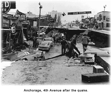
The earthquake occurred at 5:36 p.m. on March 27, 1964, Alaska Standard Time. The epicenter was in the northern Prince William Sound, about 75 miles east of Anchorage, or about 55 miles west of Valdez. The depth, or point where the rupture began, was 14 to 16 miles within the earth's crust. Nine immediate deaths occurred in the Anchorage area: five in downtown Anchorage, three in Turnagain Heights, and one at the International Airport.
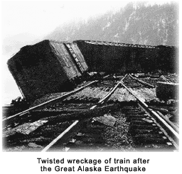
The strong ground motion reported in the Anchorage area lasted four to five minutes, some being tsunamigenic.¹ Ground liquefaction, when soil or sand briefly turns into to a liquid state, caused avalanches and rock slides. Turnagain Heights, whose pliable clay bluffs collapsed because of liquefaction, was the scene of 75 destroyed houses. Anchorage also lost its J.C. Penney building, an apartment building, the airport control tower, and several schools were damaged. To compound residents' misery, many of Anchorage's utility lines were severed. Ground deformations were extensive, with some areas east of Kodiak elevated by 30 feet and areas around Portage lowered by eight feet.
 Magnitude measurements varied, depending on the scale used. The reported Richter magnitudes ranged from 8.4 to 8.6. (Later, it was found that the Richter didn't measure accurately beyond 8.0.) The surface-wave magnitude (Ms) was 8.6. The moment magnitude (Mw) was 9.2. Most of that energy was absorbed by the ocean and land, but much man-made construction couldn't withstand the remainder.
The maximum intensity reported was XI on the modified Mercalli Intensity scale,² indicating major structural damage, and ground fissures and failures. This 12-point scale is usually shown in Roman numerals, ranging from I, (not felt/no damage) to XII (total destruction/many lives lost).
From this event, significant damage covered an area of about 50,000 square miles. Intensities of IV-V (felt by most people/minor damage) were reported as far away as Cold Bay, Bethel, McGrath, Kotzebue, Deadhorse, Fort Yukon, Eagle, and Skagway.
Earthquake-generated tsunamis
The earthquake caused a total of 115 deaths in Alaska, with 106 of them owing to tsunamis generated by a tectonic uplift of the sea floor, and by localized subareal³ and submarine landslides. The temblor occurred on a thrust fault, which was a subduction zone where the Pacific plate dives under the North American plate. The grating between the two plates created the quake. The subduction zone is part of the mighty Ring of Fire at its northern end. The ring comprises the rim of the Pacific Ocean.
The initial tsunami attained a speed of more than 400 miles per hour, reached the Hawaiian Islands, and traveled a total of some 8,400 miles. The temblor also caused at least five local slide-generated tsunamis within minutes after the shaking began. In general, slide/slump-induced tsunamis are generated within a few minutes after an earthquake begins. These five occurred at Valdez (two), Whittier, Kachemak Bay, and Seward. At the original town of Valdez, a 30-foot slab of water demolished everything, and 28 residents died. A locally generated tsunami hit Whittier, where a dozen residents perished. In Seward, a 3,511-foot section of the waterfront slid into Resurrection Bay. That created a local tsunami, causing much damage and flaming oil floating on the water. About 20 minutes after that occurred, the first wave of the main tsunami arrived. The 11 to 13 fatalities in Seward were attributable to both the local and main tsunamis. The little community of Portage was abandoned and never rebuilt elsewhere.
Cities outside of Alaska
A 4.5-foot wave reached Prince Rupert, B.C., about three hours and 20 minutes after the quake. The tsunami then proceeded to Tofino on the seaward coast of Vancouver Island, then headed up a fiord to hit Port Alberni twice, damaging 375 houses and carrying away more than 50 others. Other affected Canadian towns included Hot Springs Cove, Zeballos, and Amai. Damage in British Columbia reached an estimated $10 million Canadian ($56 million in 2006 U.S. dollars).
The tsunami swept into Crescent City, California, killing 10 persons. The total number of deaths outside of Alaska reached 16. Seiches -- sudden fluctuations in bodies of water and streams -- took place in waterways, bayous, lakes, and harbors on the Gulf Coast of Texas and Louisiana, leaving minor damage. Minor damage was inflicted on boats in Los Angeles.
Tsunamis generated by the 1964 earthquake, and their subsequent damage and loss of life, were recorded throughout the Pacific. It was the most disastrous tsunami ever to hit the U.S. West Coast and British Columbia. The largest wave height for that tsunami was reported at Shoup Bay, Valdez Inlet, at 220 feet.
Summary
Within 24 hours of the original event, 11 tremors of 6.0 (Mw) or greater followed. Aftershocks persisted for nearly a year.
The number of lives lost and cost of damage for Alaska, British Columbia, Washington, Oregon and California were:
All told, the property damage cost, much of which was sustained in Anchorage, amounted to $311 million, or $1.8 billion in 2007 dollars.
² Mercalli Intensity scale. In seismology, a scale of seismic intensity is a way of measuring the effects of an earthquake at different sites. The Modified Mercalli Intensity Scale is commonly used in the United States by seismologists seeking information on the severity of earthquake effects. Intensity ratings are expressed as Roman numerals between I at the low end and XII at the high end. The Intensity Scale differs from the Richter Magnitude Scale in that the effects of any one earthquake vary greatly from place to place, so there may be many intensity values (e.g.: IV, VII) measured from one earthquake. Each earthquake, on the other hand, should have just one magnitude, although the several methods of estimating it will yield slightly different values (e.g.: 6.1, 6.3).
³ Subareal. Above water.